
What Is A Geofence
-
1
Introduction
- 1.1 What is Geofencing?
- 1.2 How does Geofencing work?
- 1.3 What Are the Benefits of Geofencing?
- 1.4 What is Geofencing Used For?
- 1.5 How Much Does Geofencing Cost?
- 1.6 What is an Example of Geofencing?
- 1.7 Does Geofencing Track Your Location?
- 1.8 What Are the Two Types of Geofencing?
- 1.9 What Does a Geofence Look Like?
- 1.10 What is the Radius of a Geofence?
- 1.11 How Accurate is Geofencing?
- 1.12 What is the Difference Between Geotagging and Geofencing?
What is Geofencing?
Geofencing is drawing or creating virtual boundaries around specific geographic areas, geofencing enables businesses and individuals to interact with the physical world in dynamic and innovative ways. Whether it’s enhancing marketing strategies, improving operational efficiency, or adding convenience to daily life, geofencing is reshaping how we use GPS technology.
Explore geofence workflows in Fleet.Net asset tracking software and hardware options such as the Piccolo ATMS portable tracker.
How does Geofencing work?
Geofencing uses GPS, RFID, Wi-Fi, or cellular data to establish a virtual boundary around a specific location. When a device enters or exits this predefined area, it triggers a programmed response, such as sending a notification, logging the event, or activating specific actions. The process typically involves the following steps:
- Define the Geofence: A boundary is set, often using mapping tools, to determine the geofence's size and shape (e.g., circular, polygonal or custom shaped).
- Monitor Location: A device with location services enabled communicates its position relative to the geofence.
- Trigger Actions: When the device crosses the boundary, actions are executed, such as alerts, logging, or automation tasks.
What Are the Benefits of Geofencing?
Geofencing offers several advantages across various domains:
- Enhanced Security: Monitor and restrict access to specific areas or alert when unauthorized access occurs.
- Improved Efficiency: In fleet management, track vehicle movement to ensure adherence to routes and schedules.
- Targeted Marketing: Deliver location-specific offers or notifications to potential customers near a business.
- Automation Convenience: Enable smart home devices based on your presence within or outside the geofence.
- Employee Management: Monitor workforce activity and ensure employees remain within designated zones.
- Data Collection: Gather valuable insights into customer or vehicle movement patterns for better decision-making.
What is Geofencing Used For?
Geofencing has versatile applications across various industries, including:
Fleet Management: Tracking vehicle movement to ensure they remain within assigned routes.
- Asset Tracking: Monitoring the location of valuable equipment or inventory to prevent theft and ensure proper usage.
Retail Marketing: Sending promotional notifications to customers near a store.
Employee Monitoring: Ensuring workers remain in designated zones for safety or productivity.
Home Automation: Activating smart devices when entering or leaving home.
Security: Alerting homeowners of intrusions or unusual activities.
How Much Does Geofencing Cost?
Geofencing is a built in feature in many GPS tracking applications. The costs associated with GPS tracking solutions depend on the devices needed and monthly costs associated with licensing the software and cellular costs.
What is an Example of Geofencing?
Imagine a trucking company that wants to monitor when its vehicles enter or exit the yard. By setting up a geofence around the yard, the company can receive automated notifications or logs whenever a truck crosses the boundary. This helps improve operational efficiency and ensures accurate tracking.
Does Geofencing Track Your Location?
Geofencing itself does not actively track location but relies on the user’s device or GPS tracker to determine whether it has entered or exited the geofence area.
What Are the Two Types of Geofencing?
-
Static Geofencing: Fixed boundaries that don’t change, such as a store location.
-
Dynamic Geofencing: Adjustable boundaries based on real-time data or user behavior.
What Does a Geofence Look Like?
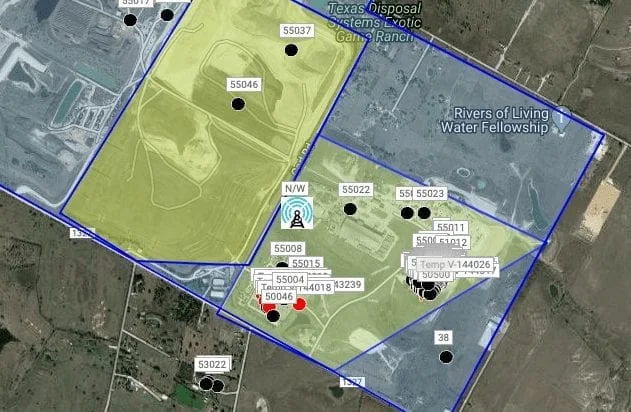
A geofence is typically visualized as a virtual circle, polygon, or custom shape overlaying a map. The exact shape depends on the platform or application used. In Fleet.Net users are able to draw geofences in any shape they see fit.
What is the Radius of a Geofence?
The radius can range from a few meters to several kilometers, depending on the use case. For example, retail applications might use a smaller radius (100-500 meters), while fleet management may require larger areas.
How Accurate is Geofencing?
Accuracy depends on the technology used:
-
GPS: Accurate within 5-10 meters.
-
Wi-Fi or Cellular Data: Less precise, with a range of 50-300 meters.
What is the Difference Between Geotagging and Geofencing?
-
Geotagging: Adding geographical information to a digital asset (e.g., photos or social media posts).
-
Geofencing: Setting up a virtual boundary to trigger actions based on location.
Get a Live Demo
Fill out the form below and a member of our team will get back to you
Article Author

Related Resources
- Best AirTag Alternatives (2026): Top Trackers for iPhone, Android, Wallets, and Business Assets January 19, 2026
- Commercial Fleet Insurance: Everything You Need to Know December 08, 2025
- CARB Compliance: What It Means and How to Stay Compliant December 04, 2025